


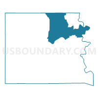
Voting District 0204, Llano County, Texas
About
Outline

Summary
| Unique Area Identifier | 675514 |
| Name | Voting District 0204 |
| County | Llano County |
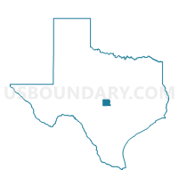
| State | Texas |
| Area (square miles) | 110.28 |
| Land Area (square miles) | 97.23 |
| Water Area (square miles) | 13.05 |
| % of Land Area | 88.17 |
| % of Water Area | 11.83 |
| Latitude of the Internal Point | 30.83860560 |
| Longtitude of the Internal Point | -98.56782250 |
Maps

Graphs
Select a template below for downloading or customizing gragh for Voting District 0204, Llano County, Texas


Neighbors
Neighoring Voting District (by Name) Neighboring Voting District on the Map
- Voting District 0004, Burnet County, TX
- Voting District 0005, Burnet County, TX
- Voting District 0007, Burnet County, TX
- Voting District 003A, San Saba County, TX
- Voting District 0101, Llano County, TX
- Voting District 0203, Llano County, TX
- Voting District 0205, Llano County, TX
- Voting District 0410, Llano County, TX
Top 10 Neighboring County Subdivision (by Population) Neighboring County Subdivision on the Map
- Burnet CCD, Burnet County, TX (14,643)
- Llano North CCD, Llano County, TX (10,497)
- Llano South CCD, Llano County, TX (8,804)
- San Saba CCD, San Saba County, TX (4,667)
Top 10 Neighboring Place (by Population) Neighboring Place on the Map
Top 10 Neighboring Unified School District (by Population) Neighboring Unified School District on the Map
- Burnet Consolidated Independent School District, TX (22,039)
- Llano Independent School District, TX (16,958)
- Cherokee Independent School District, TX (596)
Top 10 Neighboring State Legislative District Lower Chamber (by Population) Neighboring State Legislative District Lower Chamber on the Map
Top 10 Neighboring State Legislative District Upper Chamber (by Population) Neighboring State Legislative District Upper Chamber on the Map
Top 10 Neighboring 111th Congressional District (by Population) Neighboring 111th Congressional District on the Map
Top 10 Neighboring Census Tract (by Population) Neighboring Census Tract on the Map
- Census Tract 9604, Burnet County, TX (5,302)
- Census Tract 9702, Llano County, TX (3,524)
- Census Tract 9502, San Saba County, TX (3,503)
- Census Tract 9602, Burnet County, TX (2,714)
- Census Tract 9701, Llano County, TX (2,674)
- Census Tract 9703, Llano County, TX (1,837)
- Census Tract 9706, Llano County, TX (1,793)
Top 10 Neighboring 5-Digit ZIP Code Tabulation Area (by Population) Neighboring 5-Digit ZIP Code Tabulation Area on the Map
- 78611, TX (12,977)
- 78643, TX (6,139)
- 78609, TX (2,012)
- 78672, TX (931)
- 76832, TX (559)
- 78607, TX (166)